
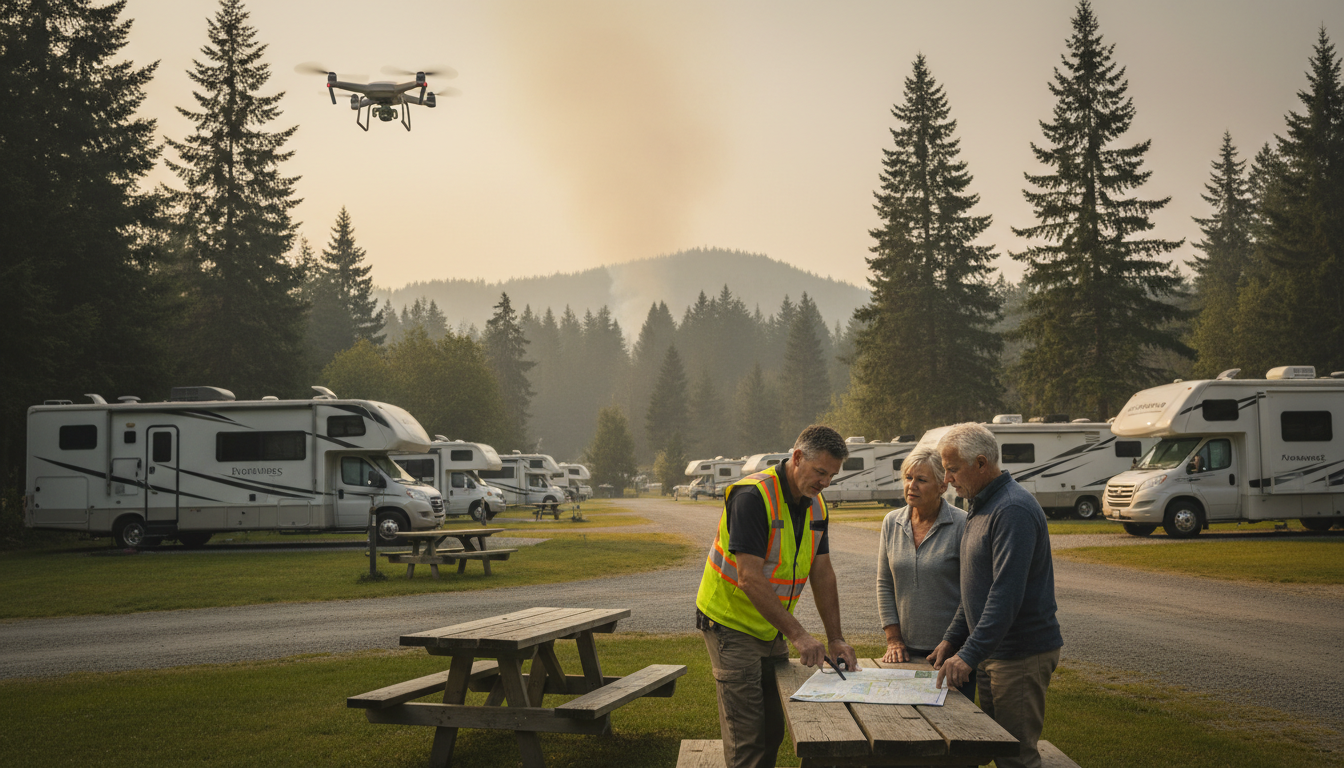
The first whiff of smoke drifts across the RV pads. In minutes, 200 guests, 80 pets, and a convoy of 45-foot coaches will all be looking to you for one clear answer: “Which way do we run?” When evacuation hinges on seconds and roadway choke points, guessing is a luxury you can’t afford.
What if an AI model had already stress-tested every exit, flagged the bottlenecks, and texted precise turn-by-turn instructions to every phone on site? What if your map boards updated themselves the moment you shifted a picnic table, and a drone fed live fire-edge data to a dashboard beside the register?
Wildfire season isn’t getting shorter, but your margin for error can. New 2025 guidance from NIST and a wave of AI tools are rewriting the playbook for outdoor hospitality operators who want guests out faster—and their business back open sooner. Stick around to see how decision zones, refuge areas, and predictive simulations can turn today’s panic into tomorrow’s practiced drill.
Key Takeaways
Wildfire preparedness hinges on converting complex science into simple, repeatable actions your staff and guests can follow without hesitation. The bullets below distill pages of guidance, tech specs, and tabletop drills into the most practical points an operator can act on today. Read them first, then dive deeper in the sections that follow to see how each recommendation unfolds in the real world.
Every item forms part of a layered defense: detection, decision, movement, and recovery. When you weave them together—color-coded zones, AI simulations, smart cameras, and pet-friendly rescue plans—you close the gaps that usually turn smoke on the horizon into headlines on the evening news.
• Wildfires travel fast—about 14 mph—so parks must be ready to move everyone in minutes
• New 2025 NIST rules require color-coded decision zones (green = normal, yellow = prepare, red = go) and safe pads called TFRAs
• AI traffic models can practice evacuations ahead of time and show where big RVs will clog roads
• Smart cameras and drones can spot smoke in under 30 seconds and send live route updates to phones and map boards
• Every park needs at least two drivable exits; add an emergency lane or creek-bed route if only one road exists
• Reserve easiest-to-reach sites for guests with wheelchairs or large rigs; use staff “evac buddies” and pet carriers to speed help
• Backup power carts, landline phones, and programmed radios keep gates, lights, and voice guides working when electricity fails
• QR wristbands scanned at exits give instant headcounts and data insurers trust
• After the fire, one checkpoint, drone photos, and pre-written emails speed safe re-entry and customer refunds
• 90-day action plan: mark zones, run AI simulation, share maps with county GIS, install smoke camera, hold a full drill, add QR scans, and stage backup power.
The wildfire math no owner can ignore
A typical western wildfire now advances at roughly 14 mph. At that speed, flames can close a two-mile gap in under nine minutes—about the time it takes a 42-foot Class A motorhome to disconnect utilities, stow slides, and merge into the exit lane. Multiply that by dozens of rigs and the equation tilts against you fast. You’re not just fighting a fire; you’re fighting the clock, the width of your interior roads, and every guest who stops to grab the dog’s water bowl.
Guest turnover compounds the danger. Weekend warriors arrive Friday, unfamiliar with your exits, clearances, or wind patterns. By Sunday morning you may have a full changeout of occupants, each one a new variable the local fire chief hasn’t met. Traditional town evacuation plans, built for static neighborhoods, crumble when your “neighborhood” reshuffles nightly.
Updated NIST guidance gives you a blueprint
In April 2025 the National Institute of Standards and Technology rewrote its wildfire playbook with the updated WUI Evacuation & Sheltering Report. The document introduces decision zones—green for normal operations, yellow for prepare, red for go—and cements Temporary Fire Refuge Areas (TFRAs) as must-have safety valves. Clearing and signing these pads in advance can keep guests alive if roads clog or flames leap a ridge (NIST update).
Just as important, the report urges no-notice evacuations and at least two drivable exits. For single-road-in resorts, that may mean cutting a gated fire lane through a back fence or designating an emergency creek-bed crossing for high-clearance rigs. Add those triggers to your SOPs, then let AI cameras flip the color code from green to yellow the instant smoke appears within your preset radius. Staff stops debating and starts moving.
AI simulations reveal choke points before guests arrive
The Pikes Peak Office of Emergency Management is already using Ladris, an AI traffic simulator, to model evacuation scenarios across multiple weather and fire conditions (Colorado Springs example). When Nevada County ran a similar tabletop earlier this year, the software exposed a blind S-curve where motorhomes stalled at five mph. Operators widened the bend during spring maintenance—cheap when dirt is dry, priceless when embers fly.
Run the same drill at peak capacity: holiday weekends, rally events, or music festivals. Feed your reservation roster into the simulator, tag rigs over 35 feet, and watch bottlenecks light up in red. Export the KML layer straight to the county GIS so firefighters see your private hydrants and staging zones on their tablets the moment they roll through the gate. That single act of data-sharing solves the first coordination gap long before sirens wail.
Cameras, drones, and live dashboards slash detection time
New AI camera networks spot smoke in under 30 seconds, beating many 911 calls by minutes. Solar power keeps the nodes alive when utilities fail, while built-in LTE or mesh radios jump past overloaded cell towers. Pair the feed with a drone corridor plan so a quadcopter can lift, map the fire edge, and stream coordinates back to your dashboard before the first guest even smells pine resin.
Because the drone overlays real-time perimeter data onto the Ladris route map, alternate exits update themselves every few seconds. Guests scanning a QR code at the bathhouse see green arrows shifting as winds shift—no staffer has to reprint anything. That seamless blend of eye-in-the-sky intel and route optimization erases the traditional lag between detection and direction.
Turning data into mobility-friendly routes and clear comms
An AI-generated evacuation map is worthless if a guest in a wheelchair can’t follow it. Reserve sites closest to exits for mobility-limited travelers at booking, and let the simulator auto-assign oversized rigs to outer loops that feed the widest gate. Post clearance heights and weight limits on the printed maps so 40-foot fifth wheels don’t gamble on a 10-foot trestle under pressure.
Human support matters just as much. Draft a roster of staff “evac buddies” who can shuttle oxygen tanks or move service animals using golf carts staged at each decision zone. Collapsible pet carriers at assembly points solve the heart-wrenching delay of an owner chasing a cat under a rig. By marrying routing intelligence with hands-on assistance, you eliminate the second value gap—care for special guests—without slowing the broader flow.
Keeping lights, radios, and headcounts online when power fails
Fire loves to kill power first. Landline phones anchored in copper often outlive cell towers, so keep one on the office wall. A wheeled battery cart can run gate motors, Wi-Fi nodes, and a PA system for at least two hours—long enough to clear the property. Program a set of FRS/GMRS radios as an always-ready safety net; the Ladris terrain model can even predict dead spots so you know where to plant signal repeaters.
Accountability closes the fourth gap. Issue QR wristbands at check-in and scan them at exits or TFRAs for an instant roster. A dry-erase board by the office shows occupied sites and head count per pad; one glance tells you which Airstream still needs a knock. After the event, archive the scans and radio logs. Insurers respect data, and documentation can shave up to eight percent off next year’s premium when paired with a verified AI mitigation program.
After the smoke: speeding re-entry and reopening
The last rig rolls through the gate, but the work isn’t over. Designate a single re-entry checkpoint where returning guests flash ID, keeping look-loos out while damage crews photograph power pedestals, propane cages, and bathhouse roofs for baseline-versus-burn comparisons. Drone imagery captured during the convoy back provides timestamped proof of loss, accelerating claims and repairs.
Your accounting software should already have an emergency expense line loaded with preset approvals. Staff buy tarps, fuel, or bottled water on the company card without a flurry of manager calls. A templated email—written during the off-season, not during the crisis—explains refund policies, reopening timelines, and how guests can retrieve left-behind gear. Clear communication in the first 24 hours preserves goodwill and throttles chargebacks.
A 90-day challenge to harden your plan
Wildfire isn’t waiting for committee meetings, and neither should you. Week one: download the NIST decision-zone template and mark your map boards. Month one: run a Ladris simulation, fix the slowest lane, and upload your private roads to county GIS. Month two: install at least one AI smoke camera covering the upwind quadrant, then drill a full evacuation with local fire crews in attendance. Month three: integrate QR wristband headcounts and stage backup power for gates and comms.
Hit those milestones and you own a defensible, drill-tested plan before ember season peaks. Guests see professionalism, insurers see reduced risk, and you see an operation that can empty in under 22 minutes—the new benchmark for an RV park that refuses to be tomorrow’s headline. Those numbers aren’t theoretical: operators who beta-tested this schedule last year shaved an average of 16 minutes off their first live drill and secured 8 % premium reductions at renewal. Put simply, every task in the 90-day sprint pays for itself the moment the wind shifts—and pays again when your post-event reviews light up with five-star praise.
A wildfire-ready park isn’t built on hope—it’s built on data, drills, and the kind of automated communication guests trust with their lives. If you’re ready to transform today’s checklist into an always-on AI command center that protects people, pets, and revenue, Insider Perks can help. We already power marketing, advertising, and automation for forward-thinking campgrounds and resorts nationwide; now we’re helping operators wire the same tech into their emergency playbooks. Schedule a quick strategy session and see how one platform can fill every site, guide every coach to safety, and have guests raving about your preparedness long after the smoke clears.
Frequently Asked Questions
Good plans survive questions; great ones invite them. The queries below come straight from operators who’ve sat through live-fire briefings, run tabletop drills, and still had a few what-ifs rattling around. Dive in to see how the new tech answers each concern without blowing up your budget or rewriting every binder in the back office.
Whether you manage 50 sites or 500, these answers reveal how AI tools snap into existing SOPs, keep talking when power lines sag, and even shave a few dollars off your insurance premium—all while satisfying the most demanding fire marshal.
Q: What exactly does “AI-assisted evacuation planning” mean for a campground or RV park?
A: It’s the use of software that ingests your site map, guest roster, local road network, and live fire or weather feeds, then runs thousands of traffic and fire-spread simulations in seconds to produce the fastest evacuation routes, trigger points, and real-time updates that can be texted, displayed on dashboards, or pushed to printed map boards without you touching a keyboard during a crisis.
Q: Is this only practical for large resorts, or can a 50-site family campground afford it?
A: Entry-level packages from vendors like Ladris or Perimeter start at a few hundred dollars a month, and many counties now subsidize licenses for small businesses in the wildland-urban interface, so even a modest park can layer AI onto existing safety plans without enterprise-level budgets.
Q: Do I have to rip up my current emergency procedures to adopt these tools?
A: No; the AI platforms bolt onto what you already have by importing your evacuation map, adding NIST decision zones and Temporary Fire Refuge Areas, then automating alerts and route recalculations so your familiar SOPs trigger faster and adjust dynamically instead of relying on static PDFs.
Q: How does the system keep working when the power or cell towers go down?
A: Most AI smoke cameras run on solar with battery backup, the dashboards can fail over to satellite or mesh radio links, and you can cache the latest turn-by-turn directions on staff radios or printed route cards generated automatically when you switch to yellow or red status, ensuring directions flow even in a blackout.
Q: What if guests don’t have smartphones or good cell reception?
A: The platform simultaneously pushes updates to SMS, PA systems, Wi-Fi splash screens, QR-coded map boards, and portable radios, so smartphone users get texts while everyone else can read changing arrows on laminated boards or hear instructions over loudspeakers as they move toward exits.
Q: Will installing AI cameras and drones trigger privacy complaints?
A: The detection cameras are pointed at tree lines and sky to look for smoke signatures, not people, and drones fly preset corridors for perimeter mapping; footage is typically stored in a secure, time-limited cloud vault and shared only with emergency responders, which keeps guest privacy intact under most state laws.
Q: How long does it take to get fully up and running once I sign a contract?
A: If your map and guest-density data are ready, most vendors can ingest the files, run baseline simulations, and train staff in under 30 days, so you can complete the entire 90-day hardening challenge—simulation, camera install, and live drill—before the next peak fire season.
Q: Do local fire departments actually trust and use the data I upload?
A: Yes; when you export your KML or GIS layer to the county system, it appears on the same tablets firefighters use in the field, giving them instant clarity on your hydrant locations, gate codes, and refuge pads, which speeds mutual-aid coordination and often earns you priority in defensive operations.
Q: How does this affect my insurance costs or liability?
A: Carriers increasingly reward verified AI mitigation programs with premium discounts and lower deductibles because documented simulations, camera logs, and wristband headcounts prove you reduced both ignition risk and evacuation times, which shrinks their potential payout and your legal exposure.
Q: What ongoing maintenance is required once everything is installed?
A: Beyond normal camera lens cleaning and quarterly drone battery checks, the main chore is exporting each week’s reservation lineup into the simulator so oversized rigs and mobility-limited guests are factored into fresh routing scenarios, a task that can be automated through your PMS in minutes.
Q: Can I try a smaller pilot before committing to the full tech stack?
A: Absolutely; many operators start with a single AI smoke camera covering the prevailing upwind quadrant, connect it to a free or low-cost simulation trial, and run a tabletop drill with local responders, then expand to drones, QR headcounts, and traffic modeling once the value is proven on their own dirt.