
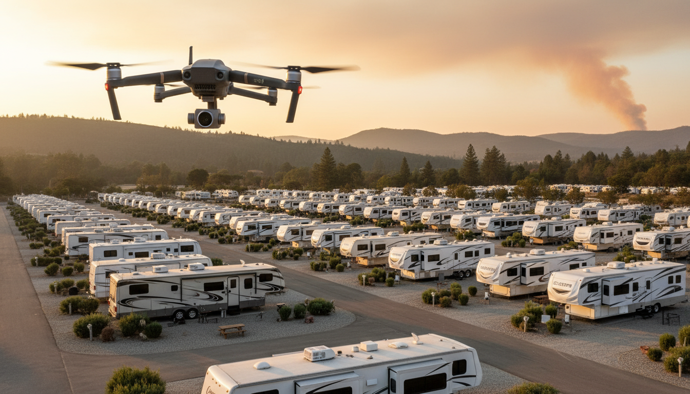
Your guests came for crackling campfires and star-filled skies—not a frantic 2 a.m. knock that sends families scrambling to pack up in the dark. What if you could spot the first whiff of combustion miles away, watch a 3-D smoke plume build in real time, and decide—before anyone smells a thing—whether tonight’s s’mores stay on schedule or the evacuation plan goes live?
From gas-sniffing sensor posts to AI-guided drone swarms mapping every ember-driven updraft, the technology exists right now to put a virtual fire lookout tower over your park—no overtime, no guesswork, no blind spots. Ready to see how operators are slashing response times from hours to seconds… and turning that live risk map into both a safety net and a marketing edge? Keep reading—because the next wildfire season is already lining up.
Key Takeaways
– Fires move fast; every minute counts
– Sensors smell smoke first, then alert the system
– Drones auto-launch, snap pictures, and map heat and smoke
– A simple screen shows green, yellow, or red risk levels
– Early warnings give campers extra time to leave safely
– Start small: two sensors and one drone, add more later
– At least one staff member needs an FAA Part 107 license
– Monthly drills turn data into quick, clear action
– Texts, maps, and signs guide guests without panic
– Grants and insurance discounts can cover most costs
– Showing live safety info builds trust and boosts bookings.
Those bullet points form the blueprint behind every success story you are about to read. They compress a wall of technical jargon into pocket-size marching orders your whole team can memorize before lunch. As you move through the sections below, keep circling back to this list; each headline simply expands one or two of these essentials in more depth.
Taken together, the takeaways reveal how early detection marries hardware, software, and staff training into a single workflow. They also hint at the hidden upside: marketing credibility that wins repeat bookings and insurance perks that pay the bills. Build one layer at a time and your campground graduates from reactive to predictive without blowing up next year’s capital plan.
Minutes vs. Megawatts: Why Speed Shapes Wildfire Outcomes
Seventy percent of U.S. campgrounds sit inside the Wildland-Urban Interface, that fuzzy boundary where a stray spark can jump from public land to picnic table in a heartbeat. Once flames breach the tree line, RV evacuations often take two or three times longer than car departures because guests must retract slide-outs, disconnect utilities, and jockey rigs through narrow lanes. Every additional minute of warning can be the difference between an orderly rollout and grid-locked panic.
Lost revenue compounds the stakes. A single smoke-closure weekend in July can erase an entire month of profit, pushing occupancy forecasts off-track and triggering cascades of refund requests. Operators who cut detection time from hours to seconds buy themselves the buffer needed to keep trails open, adjust activity schedules, or launch a staged evacuation while roads are still clear.
From Lab Demo to Launch Pad: Breakthroughs Ready for Check-In
Last fall, a team at the University of Minnesota flew autonomous swarms straight into wildfire columns, sampling particulates at multiple elevations and generating second-by-second 3-D smoke maps (Minnesota drone swarms). The result: operators can now see not just where flames are, but where heat and smoke will drift next—intel perfect for deciding if a hillside of premium sites should stay open or go on standby. That “look ahead” capability beats static perimeter alarms because it forecasts discomfort, not just destruction.
On the commercial front, Dryad Networks’ Silvaguard system links solar gas sensors to drones that auto-launch the instant they smell combustion. Within minutes, infrared and optical images—complete with GPS coordinates—appear on a dashboard, giving staff a verified ignition snapshot before a single guest spots smoke (Dryad case study). Small parks love the starter pricing; larger resorts love the API that feeds data into existing property-management software, proving that innovation scales both up and down.
Meanwhile, the USDA Forest Service tweaked image-processing settings so a lone mapping drone can survey roughly 100 forested acres per hour, deliver tree-level fuel metrics within six hours, and cut storage needs by about seventy-five percent (USDA fuel mapping). Translation: you don’t need a server farm or GIS PhD—just a laptop in the office and a checklist beside the coffee pot. Less data wrangling means faster insight and lower cloud bills.
Building a Digital Lookout Tower in Five Layers
Picture a mesh of waist-high sensor posts tucked along trails and service roads. They sniff for volatile gases, feeding data back to a base station that green-lights an auto-launch drone the instant thresholds spike. The drone hovers 200 feet up, toggles to infrared, and beams live imagery to a browser tab next to your reservation calendar. Add the optional Minnesota-style swarm to widen situational awareness; import the USDA presets so the office laptop renders fuel maps before dinner check-ins conclude.
Because each layer is modular, you can start small—two sensors and one drone—and stack on complexity as budgets allow. What matters is latency: the system updates faster than state fire alerts, is geofenced precisely to your property lines, and can kick off pre-defined evacuation tiers in a single click. Expand sensor density for pinpoint detection, or add LTE backup for redundancy—the architecture grows like Lego bricks, not a monolith.
Clearing the Flight Path: Compliance Without Headaches
Regulators love paperwork; guests love fireworks. Bridging those worlds starts with at least one staffer holding an FAA Part 107 certificate and printed credentials ready for surprise inspections. Every airframe must be registered, marked, and logged. Morning routine now includes a quick LAANC check for temporary flight restrictions—especially vital during regional blazes when tanker aircraft crowd the sky.
Cap autonomous missions at 400 feet above ground unless you hold a waiver, and program altitude and geofence limits right into the flight controller. A one-page letter of agreement with the nearest fire-dispatch or bomber base ensures your drones are listed as an early-warning asset, not a nuisance, so no one grounds you when detection matters most. Round that out with a clear privacy policy posted at check-in and on your website to head off concerns about backyard barbecues appearing on social media feeds.
People and Process Turn Pixels Into Protection
Tech shines only when humans know what to do next. Designate a Drone Safety Officer who owns pre-flight checklists, battery-health logs, and monthly mock-drill scheduling. Cross-train at least two maintenance crew members for redundancy; vacation gaps should never stall fire coverage.
Every month, run a 15-minute tabletop drill: pull up yesterday’s map, assign a color tier—green, yellow, or red—and decide whether to keep trails open or trigger SMS alerts. Repetition turns numbers into instinct and turns dashboards into decisive action. After each real flight or near-miss, debrief openly during staff meetings; incremental lessons prevent headline-making accidents down the road.
Infrastructure Choices That Won’t Scare Guests
The drone nest belongs about thirty feet from propane cages and guest footpaths, ideally shielded from errant Frisbees and gasoline fumes. Outfit it with a lithium-battery fire blanket and a small solar panel tied to a battery bank or existing UPS, so liftoff remains possible even when grid power fails. Visible yet unobtrusive placement tells guests you prioritize safety without turning their vacation into a tech expo.
A dedicated hardline or private Wi-Fi channel keeps 4K images from cannibalizing guest bandwidth; no one wants their movie night buffering because the resort is downloading infrared footage. Schedule firmware updates and sensor calibrations on the same calendar that reminds staff to test pool chemistry—one routine, zero surprises. Over time, even skeptical visitors adjust to the low hum of rotors as just another part of the landscape, like golf carts or maintenance pickups.
Turning Sensor Data Into Swift Action
Pre-define risk tiers that every employee can explain in one sentence: green means routine, yellow bumps patrol frequency, red starts a staged evacuation. Link the dashboard directly to your SMS platform and PA system so one button broadcasts instructions park-wide. Automating that hand-off shortens the decision loop and removes guesswork when adrenaline spikes.
Hard-laminate site maps with muster points and vehicle-flow arrows; stash copies in cabins, ranger carts, and at the registration desk. Conduct live evacuations twice a year during shoulder season when occupancy is low, and invite local fire officials to observe. Their feedback tunes your trigger thresholds to match the command structure they will use in a real event, making collaboration seamless.
Safety Sells: Turning Tech Into Guest Experience
Simple signage near the entrance—drones operate for fire safety only—reassures privacy-minded travelers and positions your park as forward-thinking. Push the daily fire-risk level and any air-quality advisories through your app or text system by 9 a.m. Guests planning hikes love proactive updates; parents of asthmatic kids love them even more.
Mount the live risk map on a lobby monitor. The dancing colors showing safe conditions don’t just calm nerves—they advertise that your team scouts danger before it arrives. Sprinkle wellness tips beside the display—hydrate, avoid strenuous climbs when smoke is moderate—and you transform an abstract warning into practical value guests remember when booking next year.
ROI, Grants, and the Payback Clock
Expect to spend four to six thousand dollars on two sensors and one auto-launch drone—hardware that often qualifies for state Wildland-Urban Interface mitigation grants or insurance-company rebates. Preventing a single smoke-closure weekend or securing a five-percent break on premiums offsets most first-year costs. Savings compound when word-of-mouth drives new bookings and repeat guests refuse to camp anywhere else.
Scale up as budgets allow: add swarm mapping for broader coverage, expand sensor density for pinpoint detection, or integrate the API into your PMS to generate automated incident reports. Each layer compounds protection and marketing punch, raising property valuation in the eyes of lenders and prospective buyers. Safety becomes a revenue multiplier, not just a cost center.
The future of fire safety is hovering right above your treetops—turn it into a signature amenity before the next red-flag warning hits. Whether you start with two sensors or a full autonomous swarm, the story writes itself: proactive protection, data-driven decisions, and guest peace of mind. Let Insider Perks weave that story into your branding, automate the alerts that keep rigs rolling smoothly, and broadcast your “always-on lookout” across every channel your future guests scroll. Ready to see how marketing, AI, and automation can make your new digital watchtower pay dividends long after wildfire season ends? Reach out today and let’s map the safest—and most marketable—path forward together.
Frequently Asked Questions
Q: My park already gets state fire-alert texts; why invest in our own drones and sensors?
A: State and federal alerts are issued only after a fire is confirmed, which can be 10–60 minutes after ignition; a property-bound system detects gas signatures or heat on your acreage in seconds, giving you a head start on evacuations, guest messaging, and route control that mass alerts simply can’t match.
Q: How much acreage makes a system like this worthwhile—does a 30-site campground really need it?
A: Fire risk is measured less by size than by proximity to fuel and evacuation complexity; even a compact park surrounded by forest can face hour-long RV rollouts, so shaving minutes off detection is as valuable for 30 sites as for 300, and the starter kit scales down without penalties.
Q: What is the typical upfront cost and how fast do operators see payback?
A: Entry packages of two gas sensors, one auto-launch drone, and software licensing run between $4,000 and $6,000; most parks recover that in one to two seasons through avoided smoke-closure refunds, a 3-5% break on insurance, or a single early-detection event that prevents damage claims and negative reviews.
Q: Do I need an FAA Part 107 license if the drone flies itself?
A: Yes—any commercial use, autonomous or manual, requires at least one staff member with Part 107 certification to file flight logs, request LAANC approvals, and serve as the legal remote pilot in command during every mission.
Q: How do we keep guests from worrying that drones are filming their campsites?
A: Post clear signage and include a privacy clause at check-in stating that flights are limited to fire-detection sensors and infrared imaging, not guest areas; the platform also time-stamps and geofences footage so you can audit and prove compliance if questions arise.
Q: What about high winds, heavy smoke, or night operations—will the drone still launch?
A: The flight controller checks local wind and visibility thresholds before takeoff; if conditions exceed safe limits, the ground sensors still provide alerts and you can manually escalate while the drone waits for a weather window, and Part 107 rules already allow night flights with anti-collision lighting.
Q: How intensive is staff training beyond the Part 107 pilot?
A: Most operators designate a Drone Safety Officer and cross-train one backup; each spends about eight hours on vendor tutorials and two or three mock drills before being comfortable running missions and interpreting dashboards.
Q: Can the system feed directly into my campground management software or SMS tool?
A: Most commercial platforms expose a REST or webhook API that lets you push sensor thresholds, GPS coordinates, and threat tiers into popular PMS and messaging apps so guests receive automated texts and your incident reports archive under the same reservation record.
Q: Are false alarms common, and how are they handled?
A: Gas sensors flag only combustion-specific signatures and require two consecutive threshold breaches before triggering a drone launch; if the drone’s infrared camera sees no heat anomaly it clears the alert automatically and logs the event for review, keeping nuisance warnings rare.
Q: What happens if the power or internet goes down during a regional fire?
A: The drone nest’s battery bank and a small solar panel keep the system live for 12–24 hours, while local Wi-Fi mesh or LTE fallback maintains data links; if all connectivity fails, the drone will still record imagery locally and return to base so you can review after service restores.
Q: Will installing this equipment lower my insurance premiums?
A: Underwriters increasingly treat on-site early-detection technology as a risk-mitigation measure; operators report premium reductions between 3% and 8%, and many carriers reimburse part of the hardware cost or waive deductibles after a documented early-alert saves property.
Q: Are grants available to offset purchase costs?
A: Yes—state Wildland-Urban Interface mitigation funds, FEMA pre-disaster grants, and some rural broadband or tourism resiliency programs all list early-detection sensors and drones as eligible expenses, and vendors often help package the application paperwork.
Q: How often do sensors and drones need maintenance or replacement?
A: Plan on quarterly sensor calibration, monthly firmware checks, and lithium battery replacement every two to three years; the airframe itself typically lasts 800–1,000 flight hours, translating to five or more seasons for most parks running one or two missions a day.
Q: Could local fire agencies shut down my flights during an active blaze?
A: Establishing a letter of agreement with the nearest dispatch center and filing real-time LAANC requests tags your drone as an allied asset in their airspace management software, so instead of grounding you they’ll often use your feed to sharpen their own situational awareness.