
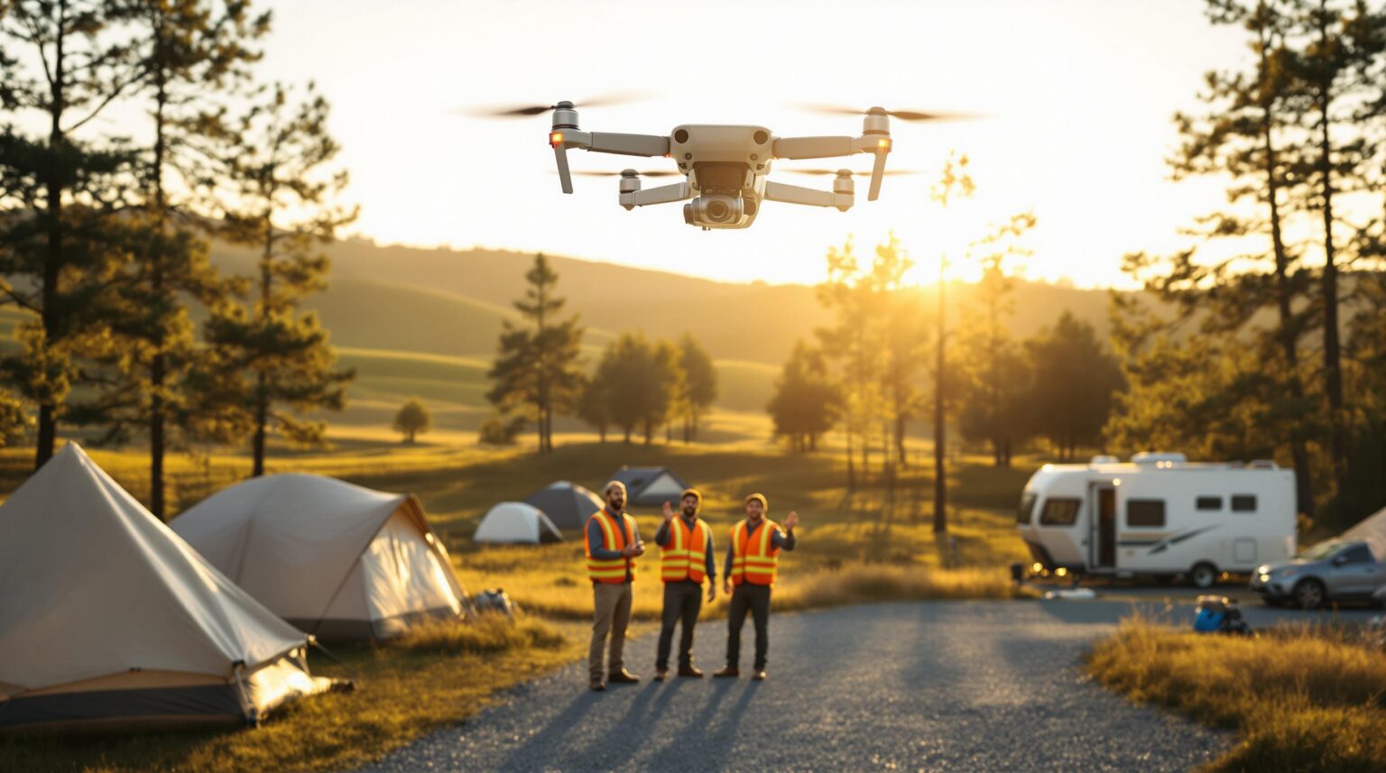
Every spring you walk the grounds, crossing your fingers that winter didn’t leave sinkholes under site 14 or a dead tree leaning over the new glamping dome. Imagine swapping that foot-slog for a 10-minute drone sweep that spots every cracked culvert, loose shingle, and crowd-pleasing selfie angle—then drops the intel straight into the software you already use to assign sites and schedule repairs.
Shared drone mapping lets neighboring parks split the cost of high-resolution aerial surveys while each of you banks the full payoff: fewer surprise work orders, safer trails, and drone-shot hero images that sell cabins before guests even click “Book.” Ready to see how a single flyover can plug into your maintenance plan, marketing funnel, and guest-safety playbook—all while staying FAA-compliant and budget-friendly? Keep reading; the sky’s about to make your job a lot easier.
Key Takeaways
When time is short and budgets tighter, this cheat-sheet shows exactly why shared drone mapping belongs on your spring-prep checklist. Scan the bullets, share them at your next owner meeting, and keep them handy when a board member asks, “Why drones, and why now?”
• A 10–15 minute drone flight can find hidden problems—like cracked culverts or loose shingles—before they turn into big bills
• Fixing issues early often saves parks thousands of dollars and avoids site closures
• Sharing a drone service with nearby parks can cut survey costs by about 40 percent
• One flight supports three teams at once: maintenance (repairs), marketing (photos & tours), and safety (crowd or rescue views)
• Regular quarterly flights create a time-stamped map to track slow changes such as erosion or tree growth
• Use only FAA-certified pilots, post “Drone in Use” signs, and log every dollar saved to prove ROI
• Follow a simple 90-day rollout: Month 1 plan, Month 2 first flight, Month 3 review and adjust
• Pick vendors who know RV parks so their files drop right into your reservation or GIS software.
Keep these points close as you explore the real-world stories and rollout roadmaps below—they’ll anchor every benefit and steer you toward a payback that shows up on the very first flight report.
Opening Scene: A 15-Minute Flight That Saves $15,000
Pine Ridge RV Resort booked a shared-service drone sweep one rainy April morning. Fifteen minutes of flight produced an orthomosaic map that flagged an eroding culvert hiding beneath the main loop road. The maintenance crew patched it for $2,500—before a midsummer washout would have forced a $15,000 rebuild and two weeks of site closures.
Back in the office, the operations manager overlaid the high-resolution imagery onto the park’s existing GIS map and color-coded the repair zone. He then logged the avoided cost in a shared spreadsheet that tracks drone-identified savings, immediately showing a 600 percent ROI on the first flight. Marketing edited a before-and-after gif from the same footage and posted it to Facebook, generating hundreds of engagements and three new group bookings within 48 hours.
Why Shared Drone Services Beat One-Off Hires
Traditional one-off drone hires work like calling a plumber in peak season—expensive and reactive. A shared-service model spreads the mobilization fee across sister parks or departments, trimming per-mission costs by as much as 40 percent. Bundled quarterly flights create a time-stamped archive that shows seasonal changes, perfect for spotting slow-burn issues like shoreline creep or tree-canopy growth.
Because one capture can serve maintenance, marketing, and safety, you avoid paying three vendors for three separate shoots. Marketing slices the footage into reels; operations imports the GeoTIFF into GIS tools; security overlays thermal imagery during festival weekends. One flight, three wins—plus the goodwill of neighboring properties sharing the same asset and swapping best practices with every download link.
Core Benefits for Outdoor-Hospitality Operators
High-resolution site mapping replaces guesswork with centimeter-grade data. Orthomosaic layers reveal grade, drainage paths, and canopy density; staff can reroute foot trails away from low-lying muddy spots before guests complain. Companies such as Veuwr Aerials deliver GeoTIFF and OBJ files that drop directly into reservation or GIS platforms, eliminating the need to redraw site boundaries by hand.
Preventive maintenance is where the real savings stack up. Routine flights pick up hairline roof cracks, leaning trees, and asphalt alligatoring long before those issues chew through labor budgets. Add a “drone-identified tasks” line to your weekly maintenance meeting, and the imagery shifts from pretty picture to actionable punch list.
Marketing enjoys a collateral windfall. Bird’s-eye clips stitched into interactive tours through platforms like TillerXR give prospective guests a choose-your-own-campsite experience that reduces booking friction. Operators report lower pre-arrival phone calls and higher reservation confidence because visitors already know which pad fits their slide-outs. Those same clips double as social-media hooks that boost engagement without more ad spend.
Guest safety rounds out the quartet of benefits. Thermal sensors can locate a lost hiker before nightfall, while live feeds monitor large events for unauthorized after-hours activity. In Wisconsin county parks, rangers now use drones during music festivals to keep foot traffic flowing and alert EMTs when crowds bottleneck, proving aerial awareness saves more than dollars—it can save lives.
Closing the Gaps to Make Drones Work Day One
Regulatory compliance starts with the pilot. Verify a current Part 107 Remote Pilot Certificate, insist on proof of aviation insurance, and review the FAA UAS Facility Map for airspace restrictions before every flight. On the ground, post “Drone Operations in Progress” signs to calm privacy concerns and schedule missions outside dawn and dusk quiet hours to respect wildlife.
Budget clarity follows compliance. Track avoided costs—culvert repairs, tree removals, roof patches—in a shared ledger. Many parks recoup the quarterly flight fee within the first season. Store raw imagery in a cloud folder with a date_location_altitude naming convention, back it up offline each quarter, and restrict edit access so staff always work from a single source of truth. Finally, choose one drone liaison to order flights, circulate findings, and color-code map layers; focused responsibility prevents the program from stalling and keeps the ROI story straight.
Vendor Selection & Partnership Blueprint
Niche providers like Veuwr Aerials cater specifically to RV parks, bringing terrain analytics, FAA expertise, and reservation-software integrations baked in. Generalist pilots can work, but you’ll spend extra time explaining dump-station layouts and pull-through angles. When evaluating bids, ask about data delivery formats, turnaround time, insurance limits, and contract clauses such as a no-fly window during peak wildlife movement. A clear written agreement up front prevents finger-pointing later.
Consider bundling services beyond imagery. Some vendors now offer AI overlays that flag drainage issues automatically—an emerging capability highlighted by Martrek Digital. Pairing AI analysis with regular flights gives you predictive maintenance instead of reactive patch jobs, turning the drone’s eye into a forecasting tool that spots tomorrow’s trouble before breakfast.
Implementation Roadmap: 90 Days to Routine Operations
Month 1 focuses on scoping. Identify neighbor parks willing to share flights, map out airspace, and lock in a quarterly cadence. Pull last year’s maintenance invoices so you can benchmark avoided costs once imagery starts flowing.
Month 2 brings the first capture. Post guest signage, choose a mid-day slot to minimize wildlife disturbance, and rotate takeoff points to avoid soil compaction. After the flight, host a 30-minute workshop where the drone liaison walks groundskeepers and front-desk staff through the new map. Shared understanding turns pixels into punch lists and builds cross-department excitement.
Month 3 is all about refinement. Log every avoided cost, tweak flight paths based on staff feedback, and decide on contract renewal armed with hard numbers. By then, the drone program feels less like tech experimentation and more like a standard utility—no different from electricity or Wi-Fi.
Micro-Case Studies
Campground Views adopted 360-degree drone video and saw average stay length bump by almost a full night. Guests reported that virtual previews removed the anxiety of choosing the wrong pad, leading to longer bookings and fewer cancellations. Front-desk staff noticed a lighter phone load, freeing them to upsell firewood bundles and kayak rentals instead of describing site sizes.
A KOA franchisee layered TillerXR virtual tours over their drone imagery and measured an 18 percent drop in pre-arrival calls. Staff reclaimed phone hours, and the marketing budget stretched further because a single flight supplied both inspection data and social-media gold. Management used the saved labor hours to launch a weekly s’mores social, boosting on-site spend and guest reviews in one tasty move.
You’ve seen how a single shared flyover can expose hidden hazards, feed your maintenance schedule, and flood your socials with awe-inspiring footage. Now imagine coupling that sky-high clarity with a ground-game that never sleeps. Insider Perks takes the data your drone delivers and runs it through marketing, advertising, AI, and automation engines that fill more sites, shorten task lists, and amplify every pixel into profit. Ready to turn aerial insight into all-season occupancy? Connect with Insider Perks and let’s map out your next record-breaking year.
Frequently Asked Questions
Q: What does a shared drone mapping package typically cost for a mid-size campground?
A: Pricing varies by region and acreage, but most operators report $800–$1,200 per quarterly flight when two to four neighboring properties split the mobilization fee, which is roughly 40 percent less than commissioning a solo mission.
Q: How do I find nearby parks willing to share the service?
A: Start with owners you already swap equipment or marketing ideas with, then ask your state campground association or local tourism bureau to introduce other parks within a 15-mile radius; proximity keeps flight logistics simple and everyone benefits from the same seasonal weather window.
Q: Will guests complain about privacy or noise when the drone is flying?
A: Operators who post “Drone Operations in Progress” signage, schedule flights mid-day after check-out, and include a short FAQ in the pre-arrival email rarely see complaints because guests understand the purpose and the aircraft is aloft for less than 20 minutes.
Q: Do I need an FAA license myself to use the imagery?
A: No, only the pilot must hold a Part 107 Remote Pilot Certificate; as the property owner you are the client and can legally use the deliverables for maintenance, marketing, and safety so long as the pilot handled airspace authorizations.
Q: What file formats will I get and can they plug into my reservation or GIS software?
A: Reputable vendors supply GeoTIFF orthomosaics, OBJ or LAS 3-D models, and MP4 video clips that drag-and-drop into most GIS platforms and integrate with popular reservation tools like Campspot, RMS, and Newbook via simple map overlays.
Q: How often should I schedule flights to see real maintenance value?
A: A quarterly cadence—early spring, midsummer, early fall, and post-leaf drop—captures the key seasonal changes that affect drainage, canopy, and wear patterns without overwhelming staff with data.
Q: What happens if weather cancels the scheduled mission?
A: Contracts usually include a 30-day reschedule clause; the pilot monitors wind, rain, and visibility and will rebook at no extra cost within the agreed window so you still get timely imagery.
Q: Does the vendor carry insurance in case the drone crashes on my property?
A: Professional operators carry at least $1 million in aviation liability and list your park as an additional insured; always request a Certificate of Insurance before approving a flight.
Q: How quickly will I see a return on investment?
A: Most parks recoup the annual fee in the first season through avoided repairs—think patching a $2,500 culvert instead of rebuilding a $15,000 road section—plus incremental revenue from enhanced marketing visuals.
Q: Can the same flight footage be used for promotional videos without extra licensing fees?
A: Yes, shared-service agreements typically grant you unlimited commercial rights to all imagery captured over your property, so you can slice the footage into social reels, website banners, or virtual tours at no additional cost.
Q: Will drone flights disturb wildlife in glamping areas set near forests or wetlands?
A: When scheduled outside dawn and dusk quiet hours and conducted at 150-200 feet AGL for no more than 20 minutes, flights have minimal impact on fauna, and many vendors build a no-fly buffer over sensitive habitats into the mission plan.
Q: How do I secure and store the large data files long term?
A: Most operators maintain a cloud folder with date and location naming conventions and then back up the raw files quarterly to an external drive stored off-site, ensuring the imagery remains intact for warranty claims, insurance documentation, and multi-year trend analysis.
Q: What if my park sits inside controlled airspace near a small airport?
A: Your pilot can request a Low Altitude Authorization and Notification Capability (LAANC) clearance in minutes for most Class B–E airspace; if the request is denied, the flight can still proceed at a lower altitude or be scheduled for an adjacent launch site outside the restricted zone.
Q: Can thermal imaging really help with guest safety?
A: Absolutely; a quick thermal pass during large events can spot crowd bottlenecks, overheating equipment, or even locate missing pets or hikers after dark, giving staff actionable intelligence while the situation is still manageable.