
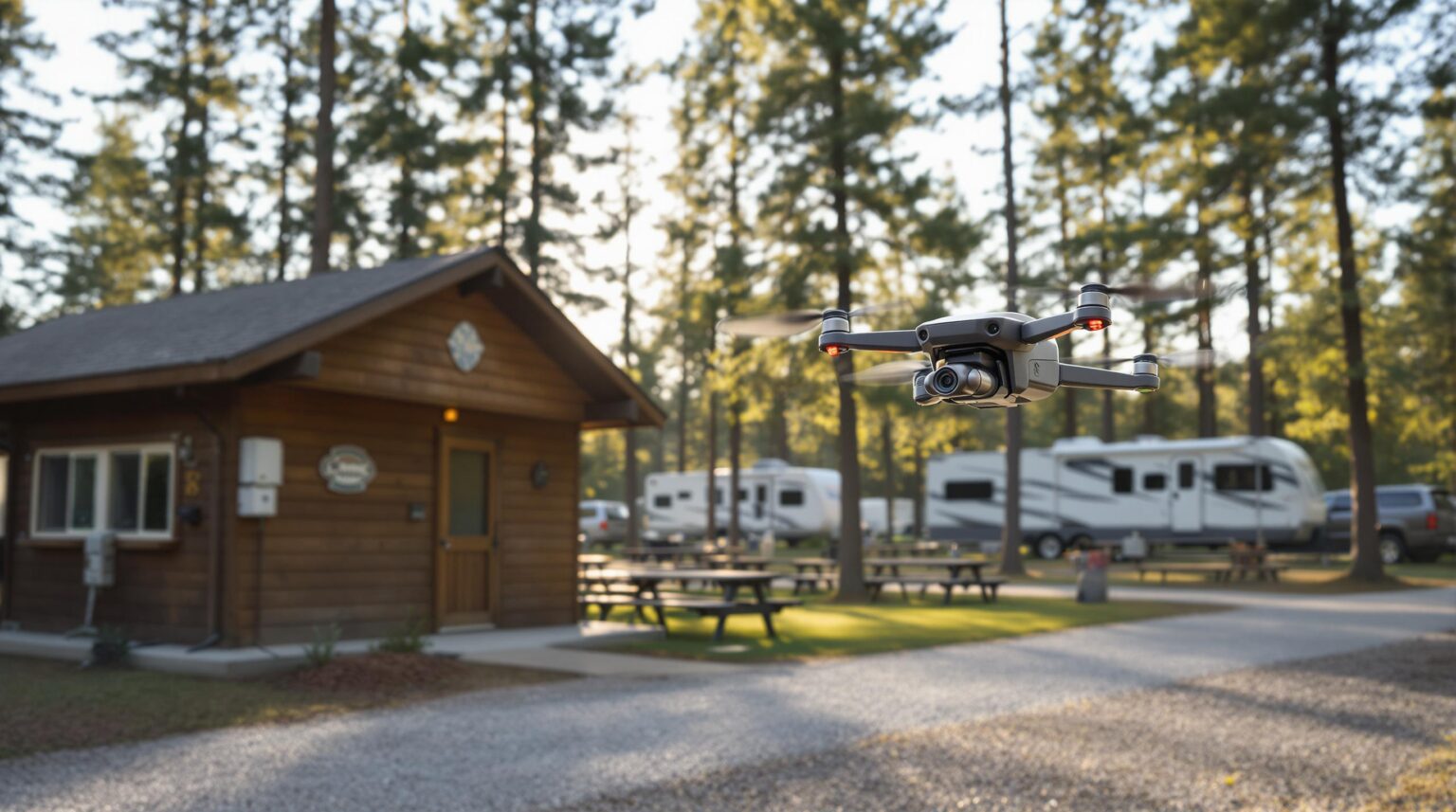
What if you could check every rooftop, trail bridge, utility pole, and storm drain in your park—without climbing a ladder, closing a section of sites, or paying overtime?
New FAA waivers are turning that “what if” into standard practice. Autonomous drones can now fly Beyond Visual Line of Sight, scan your entire property in minutes, and deliver high-resolution maps that flag leaks, corrosion, or encroaching trees before guests ever notice a problem.
Skip the rope harness and clipboard. Tap “launch,” sip your coffee, and let the drone handle the hard-to-reach inspections while you focus on bookings and guest experience. Read on to see how early adopters are squeezing weeks of maintenance into a single morning flight—and getting the ROI to prove it.
Key Takeaways
– New 2025 FAA rules let drones fly far without a watcher on the ground.
– One flight can scan every roof, bridge, pole, and drain in minutes.
– Cameras, heat sensors, and LiDAR spot leaks, rust, and leaning trees early.
– Early fixes save big money and keep guests from seeing problems.
– Fewer ladders and climbs mean safer, faster work for staff.
– Track time and dollars saved; most parks win back whole workdays each month.
– Start small, use a service or buy your own drone, and add flights each season.
– Keep pilots licensed (Part 107) and store flight plans and photos safely online.
– Post flight times so guests know cameras face down and wildlife stays safe.
– Next up: fleets of drones plus AI that turn pictures into instant work orders..
The regulatory green light: why 2025 changes everything
January 2025 marked a turning point when BVLOS approval eliminated the need for continuous visual contact. For campground owners, that means an autonomous aircraft can take off at dawn, circle every amenity, and land before your guests finish breakfast—all without a spotter chasing it on an ATV. Less human oversight translates into fewer labor hours, quicker inspection cycles, and more predictable scheduling that slots easily between turn-day cleanups and pool testing.
The FAA reinforced its confidence in automation by granting a vHive waiver the same month. Although targeted at solar farms, the ruling signals that multi-aircraft “fleets” could soon circle water towers, parking lots, and trail systems simultaneously. Forward-looking operators are already writing BVLOS into next season’s maintenance calendars, treating drone flights like mowing or trash pickup: routine, staff-light, and fully budgeted.
Drones reveal what eyes on ladders miss
Modern craft pack RGB cameras for razor-sharp imagery, thermal sensors to spot heat loss, and LiDAR that pierces dense foliage to expose leaning trees or eroding embankments. A single flight can light up hidden corrosion on a water tower or pinpoint a sagging utility line before a summer thunderstorm turns inconvenience into outage. By catching issues early, parks avoid emergency contractors, guest refunds, and forced amenity closures—all while keeping staff on the ground where slip-and-fall incidents can’t happen.
Consider a thermal scan that flagged a pinhole leak on a bathhouse roof. The flight cost $400 and took eighteen minutes; the leak, if ignored, would have soaked insulation, warped drywall, and required a $6,000 ceiling rebuild. Multiply that avoidance by every structure in your park and the economics become hard to ignore. Angell Surveys reports that drone inspections cut personnel risk and maintenance costs by double-digit percentages across multiple industries (drone infrastructure study).
Building a dollars-and-sense business case
Start with one zone—say all restroom roofs—and track every minute your team spends vs. what the drone spends. Owners who run this pilot commonly discover they reclaim two full workdays per month, time that can be redeployed to guest-facing upgrades or marketing campaigns. Keep the numbers clean: flight cost, labor saved, repair avoided. Those metrics become ammunition for budget meetings and bank loans alike.
Ownership isn’t the only path. Many parks outsource Year One to a drone-as-a-service company, paying per flight while sidestepping capital outlay. Once flight hours climb, buying or leasing a rig makes sense. Don’t forget the software subscription and data storage; analytics platforms are usually billed per site, per year. Finally, schedule flights at spring opening, midsummer peak, and fall closing so inspection costs dovetail with existing O&M cycles instead of feeling like new expenses.
Seamless fit with your maintenance workflow
Assign a drone coordinator—often the same person who already routes work orders. Centralizing requests prevents duplicate missions and ensures every image drops into a single maintenance queue. When thermal imagery of a roof arrives geotagged, your crew knows the exact shingle to replace and can close the ticket without guesswork.
Most CMMS platforms accept photo attachments, so integrate drone data directly rather than parking it in a forgotten folder. Cross-train two staffers—one Part 107 pilot in command and one visual observer—so compliance never hinges on a single person. Build a pre-flight checklist that mirrors your mower or vehicle checklist: batteries, prop integrity, airspace review, emergency landing zones. Familiar rhythm breeds long-term consistency.
Keeping guests comfortable and confident
Transparency turns buzzing hardware into brand trust. Post a weekly flight schedule on your guest app and bulletin board, clarifying that cameras face downward and ignore individuals. Most flights can be timed for mid-morning on checkout days, when sites are empty and noise sensitivity is low.
Entrance signage that states “Drone inspections for safety and maintenance” curbs surprise and underscores your commitment to guest well-being. Any footage retained for record-keeping can blur faces automatically, while the prettiest sunrise passes double as marketing gold on social channels. A maintenance tool that also fills your Instagram feed? That’s operational efficiency guests can see and share.
Stewardship above and below the canopy
Outdoor hospitality means wildlife is both neighbor and asset. Log known eagle nests, bat roosts, or wetland buffers into your flight-planning software and set strict geofences. Keeping at least 300 feet clear protects sensitive species and keeps your conservation reputation intact.
Rotor noise can be minimized by selecting low-dB propellers and flying higher whenever inspections allow. Avoid dawn and dusk during peak bird activity, and steer clear of breeding seasons published by your state wildlife agency. A collapsible landing pad prevents dust storms near campsites, and a quick post-flight walk ensures no prop caps or Velcro strips become micro-litter.
Compliance checklist: from Part 107 to BVLOS
Part 107 certification remains your legal baseline, along with LAANC airspace approvals for any controlled zones. Keep digital copies of every pilot’s certificate, battery log, and incident report; auditors love organized records almost as much as insurers. These documents also speed up insurance claims and simplify annual audits.
If your acreage or terrain begs for longer runs, map a path toward your own BVLOS waiver using the DroneDeploy precedent as your blueprint. Document risk mitigations, emergency procedures, and safety cases, then submit. Approvals can take months, so starting early ensures the green light arrives before next season’s rush.
Choosing hardware, software, and secure storage
Match sensors to assets: RGB for general imagery, thermal for roofs and power distribution, LiDAR for tree encroachment and topography. A mid-tier quadcopter with swappable payloads often outperforms a pricey one-trick pony. That flexibility keeps your capital costs in check as your inspection goals evolve.
Data security deserves equal weight. Store imagery in cloud platforms with role-based access so only maintenance, management, and vetted vendors see sensitive infrastructure. Set retention policies—raw footage for 60 days, annotated reports for asset life—and name files with date, area, and asset type so search takes seconds. Always keep a secondary backup, especially during storm season when you’ll need before-and-after evidence fast.
Five-step roadmap to launch your program
First, audit your site and define objectives: leak detection, vegetation control, storm documentation, or all of the above. Clear goals steer sensor choice and flight frequency. Without this clarity, even the best drone will gather data no one acts on.
Second, lock down compliance: verify pilot credentials, secure LAANC authorizations, and outline your BVLOS ambitions. Third, run a pilot mission and capture ROI metrics in a simple spreadsheet to prove value quickly. Fourth, feed the findings into your CMMS, train staff to interpret geotagged images, and refine your pre-flight checklist before going bigger. Fifth, scale up—expand coverage, add sensors, or adopt multi-drone fleets as regulations evolve.
What’s next: swarms, AI, and always-on insights
Regulators are trending toward wider approvals for autonomous fleets. Within a few seasons, simultaneous drones could map every utility pole, culvert, and cabin roof in a single swoop, feeding real-time dashboards while your staff stays focused on guest interaction. The technology curve suggests these approvals will accelerate as safety data piles up.
Pair that fleet with AI anomaly detection and raw pixels turn into instant work orders—no hours spent scrolling through footage. The vision is less screen time, faster fixes, and a property that quietly stays pristine while guests marvel at the night sky, not leaking ceilings. Early adopters will gain a competitive edge by integrating these insights into their maintenance playbooks before the rest of the market catches up.
When your maintenance routine can soar 200 feet above the tree line, the only real limit is how quickly you turn those aerial insights into action. Insider Perks steps in by weaving drone-captured visuals into AI-driven dashboards, triggering automated work orders in your PMS, and repurposing the best flyover shots into thumb-stopping ads that fill next season’s sites. Ready to pair sky-high data with ground-level revenue? Schedule a quick strategy call with Insider Perks and watch every roof, trail, and marketing funnel align as smoothly as your next autonomous takeoff.
Frequently Asked Questions
Q: Do I need a pilot’s license to fly an inspection drone at my campground?
A: Yes, the FAA requires at least one staff member who flies the drone to hold a Part 107 Remote Pilot Certificate; this involves an online course, an in-person test, and a $175 fee, but once you have it you can legally perform commercial operations such as infrastructure inspections on your own property.
Q: Is a BVLOS waiver mandatory or can I start without one?
A: You can begin under standard Part 107 rules that keep the drone within visual line of sight, then apply for a BVLOS waiver when you’re ready for fully autonomous perimeter or trail flights that leave your crew’s direct view; many parks run a season or two under VLOS to build a safety record that strengthens their BVLOS application.
Q: What’s the typical startup cost for a basic inspection program?
A: Most outdoor hospitality businesses launch for $6,000–$10,000, which covers a rugged mid-tier drone with RGB and thermal sensors, spare batteries, a tablet, liability insurance, and a one-year analytics software subscription; outsourcing first flights to a drone-as-a-service firm can reduce upfront spend to a few hundred dollars per mission while you prove ROI.
Q: How quickly will I see a return on investment?
A: Owners who replace manual roof checks, ladder work, and spotter overtime often recoup their costs within one season because a single avoided emergency repair—such as a water-damaged bathhouse roof—saves several thousand dollars, not to mention reduced workers-comp exposure and staff hours redirected to guest services.
Q: Will drones bother my guests or invade their privacy?
A: Flights are usually scheduled for turnover hours when sites are empty, cameras face straight down at infrastructure rather than people, and images can be automatically blurred in software, so guests experience little more than a faint buzz overhead and gain peace of mind that you’re proactively maintaining the property.
Q: How loud are inspection drones, and can I mitigate the noise?
A: Modern quadcopters operate in the 60–70 dB range—similar to conversational speech—and you can cut perceived noise by flying at higher altitudes, using low-decibel propellers, and timing missions away from quiet hours or popular gathering spots.
Q: Do drones disturb wildlife in and around the park?
A: Proper flight planning that sets geofences around nests, roosts, and wetlands, maintains at least 300 feet of separation, and avoids dawn or dusk reduces disturbance to negligible levels and keeps you in good standing with conservation agencies.
Q: What weather limits should I observe?
A: Most inspection drones can fly in winds up to 25 mph and light drizzle, but for reliable data and minimal risk you’ll want clear skies, sub-20 mph gusts, and temperatures within the manufacturer’s stated range, postponing missions during thunderstorms, heavy rain, or dense fog.
Q: How do I integrate drone imagery with my existing maintenance software?
A: Export photos or mapped orthomosaics from the drone platform, then drag-and-drop them into your CMMS ticket or asset file so technicians see exactly where to fix an issue; many systems read standard geotagged JPEGs or PDFs, so no custom coding is needed.
Q: What liability or insurance coverage should I carry?
A: A commercial drone policy that bundles hull coverage (for the aircraft) with at least $1 million in general liability is recommended, often adding just a few hundred dollars per year to your existing property policy and satisfying both lenders and local ordinance requirements.
Q: Can the same drone footage double as marketing content?
A: Absolutely—while inspection flights collect downward-facing data, a quick second pass at golden hour with the gimbal angled horizontally can capture stunning park visuals; just segregate maintenance files from promotional media to keep asset records pristine and guest privacy protected.
Q: What happens if the drone crashes or loses signal?
A: FAA-compliant drones have automatic return-to-home logic and obstacle sensors that trigger a safe landing if communication drops, and your pre-flight checklist will identify clear emergency zones, minimizing both property damage and guest exposure.
Q: Are multi-drone “swarm” inspections legal yet?
A: The FAA’s January 2025 vHive waiver proved multi-aircraft operations are achievable, but each operator still needs explicit approval, so for now you’ll fly one drone at a time unless you secure a similar waiver that details your safety case and operating procedures.
Q: How secure is the data I collect, and who can access it?
A: Reputable cloud platforms encrypt imagery in transit and at rest, let you assign role-based permissions so only maintenance staff or select vendors see sensitive files, and allow you to set retention policies—typically 60 days for raw footage and the life of each asset for final annotated reports.
Q: What training should I provide to backup staff?
A: Cross-train at least one additional employee as a visual observer or Part 107 pilot so inspections continue uninterrupted during vacations or turnover; the FAA’s online TRUST test takes under an hour for observers, and internal drills on pre-flight checks and emergency procedures keep everyone audit-ready.